


It doesn’t matter how long you’ve been at this school; you’ve probably noticed a big problem when trying to move around campus from one place to another. It’s no secret that Willy C traffic makes it very difficult to get to lunch, and with the current construction happening it’s only been getting worse.
So, I decided that I need to create a detailed traffic report, so students can know the best times to avoid these massive herds. But I can’t write a report if I don’t have any data, for this I call you dear we are reader.
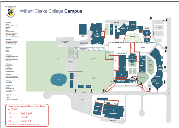
I’ve drafted a template table and need students to document the time and date of when they visit one of the main choke points on campus.
These choke points are as follows:
- The front door of the Branwhite Centre
- The bridge/Branwhite Centre access
- The gap/tunnel
- Gate 12
- Bus bay
- Building 5
- That spot between the Branwhite and the Amphitheatre
- The hallway between the oval and the cola
- Building 7
Here is a map of these chokepoints
If you wish to participate in this traffic survey, create an Excel document and create the following table.
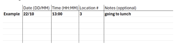
Whenever you pass one of the 9 choke points, please document the date, time (24-hour time), the assigned number of the choke point (see list above), and a note if you wish.
This survey will ideally run over 2 weeks so I can get data on weeks A and B, this means that 2 weeks after this is uploaded, I request you send your Excel document to the We Are email address (weare@wcc.nsw.edu.au) and I will then formulate the results and upload them in a second article.
TL;DR
I am conducting a traffic survey, to participate please follow the instructions above
Anyone who participates will be doing a great service to myself and the college, and hopefully this will bring attention to this big traffic situation.
Happy documenting, see all of you in a couple of weeks with the results!